

By Mary Gilbert, AccuWeather meteorologist
ACCUWEATHER-(ENEWSPF)- A powerful tornado left a trail of destruction late Sunday night in DuPage County, a suburb of Chicago, injuring numerous residents and leaving property owners picking up the pieces of their homes on Monday.
Officials from the National Weather Service (NWS) in Chicago surveyed the damage later on Monday and said on Twitter that they “found damage consistent with an EF3 rating on the Enhanced Fujita Scale in Naperville.” This was the first time in six years a tornado of EF2 force or stronger has impacted the greater Chicago area.
EF3 tornadoes can pack winds of 136-165 mph, according to the NWS.
Shortly after the tornado confirmation, reports of damage began to pour in from the affected areas. According to the NWS in Chicago, the damaging storms left more than 100 homes damaged in the southwestern suburbs of the Windy City. Multiple injuries were also reported.
The tornado initially touched down near the southern edge of Naperville, Illinois, before it tracked east through Woodridge and Burr Ridge. It was confirmed via radar with what is known as a tornado debris signature, more often referred to as simply a “debris ball.”
A debris ball can appear on radar once a tornado causes damage and lifts the debris from that damage hundreds or even thousands of feet into the air. This was the case for portions of DuPage County in northeastern Illinois on Sunday evening.
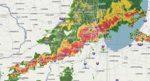
Summer truly started with a bang for portions of the Midwest on Sunday evening as severe storms tore across the region. At one point Sunday evening, severe thunderstorm watches stretched across a nearly 600-mile swath of the country from Missouri to Indiana and eastward into Michigan and Ohio.
One of the hardest-hit regions of the night was northern Illinois. Multiple severe thunderstorm warnings were issued across the northern half of the state as the summer solstice began. Unfortunately, embedded in these severe thunderstorms were several tornado-warned storms.
A line of severe thunderstorms prompted the NWS office in Chicago to issue several tornado warnings shortly before 11 p.m. CDT, Sunday.
At least one of these tornado-warned storms likely spawned a damaging tornado, and it did so in one of the most densely populated portions of the state–the greater Chicago metro.
Shortly after 11 p.m. CDT, the NWS confirmed that a “large and extremely dangerous tornado” was on the ground over far east Woodridge, Illinois.
Reports of structural damage to homes and other buildings, downed trees and downed power lines were prevalent in Woodridge. The Woodridge Police Department urged residents to stay home as some streets were “impassible due to debris and first responder activity.”
As of early Monday morning, no serious injuries were reported in Woodridge. However, in neighboring Naperville, at least six injuries have been confirmed with additional reports of residents trapped in homes.
At least 16 homes have been deemed “uninhabitable” by Naperville city officials. Officials also noted that they had received more than 120 reports of property damage.
Farther north, travelers at the Chicago O’Hare International Airport were forced to deplane and shelter in place as intense storms rolled through. Additionally, heavy rain led to flash flooding across portions of the airport compound.
Read more on ACCUWEATHER.COM.


