


AccuWeather Global Weather Center -(ENEWSPF)- AccuWeather reports severe weather is forecast to develop the Central United States into Wednesday night, impacting a similar area that saw spotty strong storms on Tuesday. A risk of flooding will follow the storms on Thursday.
Warm, moist air will surge into the central and southern Plains to the Ohio Valley at midweek.
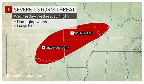
The severe weather risk area into Wednesday night is home to approximately 12 million people. The storms have the potential to bring damaging wind gusts, large hail and incidents of flash and urban flooding.
The area that could be hit by dangerous thunderstorms extends from just north of Dallas to near St. Louis, Little Rock, Arkansas, and Evansville, Indiana. Locally severe storms are likely to pass through the metro areas of Oklahoma City; Fayetteville, Arkansas; Paducah, Kentucky; and Springfield, Missouri.
People traveling through this area or spending time outdoors in the region should be on the lookout for rapidly changing weather conditions. Seek shelter indoors if a severe thunderstorm or tornado warning is issued.
According to AccuWeather.com Senior Meteorologist Henry Margusity, "While only a small number of tornadoes is likely to occur with this event, the risk for a tornado and damaging wind gusts is slightly elevated in portions of central Oklahoma to north-central Texas and northwestern Arkansas."
Should a tornado occur, it would be the first such storm of the month, not counting waterspouts. The last tornado in the United States was very weak and occurred on Feb. 23, in Kern County, California.
According to AccuWeather Enterprise Solutions Storm Warning Meteorologist Alex Avalos, "Odds are against a more robust severe weather threat from Missouri and southeastern Kansas on eastward with hail and heavy rain being the primary characteristics of the storms."
As a storm system swings to the northeast and chilly air settles in, the risk of severe thunderstorms will diminish by Thursday. However, as the severe thunderstorms collapse, several hours of drenching rain will occur from portions of Arkansas to the Ohio River Basin.
The heavy rainfall will be enough to cause streams to rise and raise new concerns about flooding toward the end of the week. Much of this region has received 3-6 inches of rain plus melting snow earlier in March.
Levels on the lower Ohio to part of the lower Mississippi rivers were hovering at minor to moderate flood stage this week, due to runoff from prior storms and thaw earlier this month.
Chilly air will continue to suppress the severe weather risk for most areas east of the Mississippi River into the weekend.


