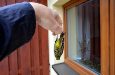
Environmental

Next Round of Winter Eyes St. Louis to Indianapolis


Expected snowfall through Wednesdahy and Thursday

AccuWeather.com-(ENEWSPF)- AccuWeather.com reports another bout of ice and snow will affect areas from the Midwest to Arkansas on Wednesday into Thursday.

After a crippling snowstorm blasted St. Louis, Mo., and Indianapolis, Ind., on Sunday, folks are surely storm weary and hoping for a lengthy break between systems.

While this will not be a major snow event with light accumulation it will be enough to cause slippery roads and some travel delays. Interstates 70, 65, 44 and 74 can be affected on Wednesday and Thursday.

After a dumping of 11 inches of snow on Sunday, Indianapolis will only have a coating to an inch or two of snow on Wednesday night into Thursday.

Farther south from Little Rock, Ark., to Cincinnati, Ohio, an icy mix of sleet and freezing rain can glaze the roads with a thin coating of ice.

Ice accumulations will be light and not the type that will bring down trees and power lines. However, caution should be exercised when driving, as roads will become slick.

Commuters in Oklahoma City could wake up on Thursday morning to a thin coating of ice on their cars.

Portions of Interstates 40, 55, 69 and 71 can be impacted by the icy conditions.

The time period of concern for areas from Arkansas to the Ohio Valley will be late on Wednesday night into Thursday morning. This is when the temperature of the air and road surfaces will be coldest and ice can accumulate on paved surfaces.

This can certainly create slow travel and delays for the morning commute on Thursday.

By Thursday afternoon, temperatures will warm sufficiently to allow for the ice to turn to rain.

Southerly winds will continue to pump warmer air into the mid-South and Ohio Valley into Friday and allow those areas to thaw from the recent chill.

By Michael Doll, Meteorologist for AccuWeather.com


ARCHIVES