Park Forest, IL—(ENEWSPF)— To anyone in the area now, take cover. The rains are falling hard. People outside will be injured, the National Weather Service warns. The warning came via the Office of Southcom Combined Dispatch Center.
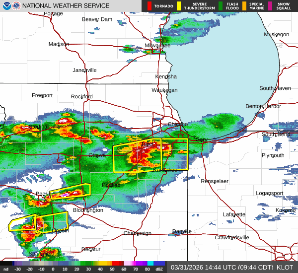
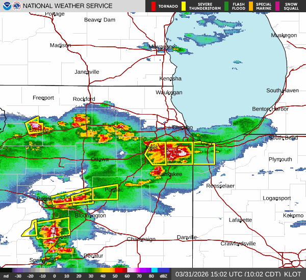
The National Weather Service in Chicago has issued a * Severe Thunderstorm Warning for… Southeastern Will County in northeastern Illinois… Northeastern Kankakee County in northeastern Illinois… Southeastern Cook County in northeastern Illinois… *

Until 1030 AM CDT. * At 928 AM CDT, multiple severe thunderstorms were located from Morris to Shorewood to Joliet. All were moving east at 40 to 60 mph. HAZARD…
Golf ball-sized hail and 60 mph wind gusts. The largest hail will fall from Mokena to Glenwood.
SOURCE…Radar indicated.
IMPACT…People and animals outdoors will be injured.
Expect hail damage to roofs, siding, windows, and vehicles.
Expect wind damage to roofs, siding, and trees. *
Locations impacted include… Orland Park, Tinley Park, Calumet City, Chicago Heights, Lansing, Oak Forest, Harvey, Blue Island, Dolton, Park Forest, Homewood, Matteson, Mokena, Bourbonnais, Frankfort, Bradley, Steger, Manteno, Peotone, Momence, South Holland, Country Club Hills, Midlothian, Hazel Crest, and Richton Park.
PRECAUTIONARY/PREPAREDNESS ACTIONS… For your protection, move to an interior room on the lowest floor of a building.
THUNDERSTORM DAMAGE THREAT…CONSIDERABLE; HAIL THREAT…RADAR INDICATED; MAX HAIL SIZE…1.75 IN; WIND THREAT…RADAR INDICATED; MAX WIND GUST…60 MPH
Source: The National Weather Service via the Office of Southcom Combined Dispatch Center


