By Kyle Elliott, AccuWeather meteorologist
AccuWeather-(ENEWSPF)- After severe storms brought widespread reports of hail and wind damage from the Plains to the Ohio Valley and interior mid-Atlantic over the weekend, a series of storm systems will renew the risk for violent storms in the central Plains and Midwest through midweek.
As has been the case over the past few days, a large dome of high pressure will maintain its position across the southern Plains and Four Corners region this week.
While this high has brought persistently hot weather to these regions, quick-moving disturbances have been zipping from west to east along the northern periphery of this heat dome.
A boundary separating the heat and humidity to the south from cooler air settling into the northern Plains and Upper Midwest will serve as the train tracks along which these disturbances will travel as it sags slowly to the south through Wednesday.
The first of these disturbances triggered explosive thunderstorm development across North Dakota and western Iowa on Monday night, with multiple incidents of hail and damaging wind gusts being reported.
“The storms in Iowa have evolved into a powerful squall line Tuesday morning, with very strong wind gusts and heavy rainfall the primary threats,” AccuWeather Meteorologist Brett Rathbun said.
The Tuesday morning commute in southeastern Iowa and west-central Illinois and northeastern Missouri will be difficult to even dangerous as violent crosswinds and blinding downpours may make it difficult for people to maintain control of their vehicle.
“On a positive note, the complex of thunderstorms that rolled through Iowa hit an important corn crop area with drenching rain,” according to AccuWeather Senior Meteorologist Jason Nicholls.
Rainfall was below average over much of Iowa during the first three weeks of August.
“This is the second big rain in three days and should help to fill out the kernels of corn growing in in the region,” Nichols said.
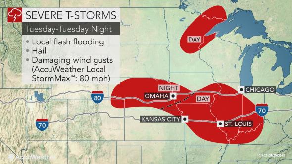
Residents in St. Louis and Kansas City, Missouri, should remain on high alert for severe weather around noontime as the storms charge rapidly through Missouri and Illinois.
AccuWeather meteorologists expect the storms to remain just to the south and west of Chicago, sparing the city from the worst of the impacts.
Meanwhile, the storms farther north will race eastward through northern Minnesota with strong winds and brief, torrential downpours through Tuesday morning.
Wind gusts can reach an AccuWeather Local StormMax™ of 80 mph, especially in Iowa, western Illinois and northern Missouri where the line will likely be most intense.
A gust to 70 mph occurred in New London, Iowa, during Tuesday morning’s storms according to a trained spotty. Winds were strong enough to topple multiple 18-wheel trucks on Interstate 80 near Case, Iowa, early Tuesday.
As the storms rolled through Springfield, Illinois, numerous trees were blown down on the west side of the city.
People in the Chicago area can expect potent storms to hit around lunchtime with downpours likely to cause slow travel on the roads and airline delays to build.
Strong winds of this magnitude can cause widespread power outages, topple trees and power lines and damage homes and gardens.
Both areas of storms are expected to weaken as Tuesday afternoon progresses and they get farther away from their energy source.
However, more storms are forecast to erupt farther west over Nebraska and southwestern Iowa during Tuesday night.
While cities such as Omaha, Lincoln, and Valentine, Nebraska, should be dry during the daylight hours on Tuesday, the weather should deteriorate rapidly overnight.
The main threats from these storms will also be damaging winds and torrential downpours.
With less steering flow on Tuesday night, the risk for flooding may be enhanced. Residents are reminded to never drive through flooded roadways and reduce speed on wet roads to reduce the risk for hydroplaning.
In all of the aforementioned areas, some of the storms may produce a few incidents of quarter- to golf ball-sized hail.
As the boundary sags farther south on Wednesday, yet another round of severe weather is in store for the Central states.
Multiple lines of storms are likely to erupt in Kansas and Missouri later Wednesday afternoon and then race eastward during the overnight hours, threatening to produce more property and home damage in the mid-Mississippi Valley.
Unfortunately, the active weather pattern may continue right into the weekend as the central Plains and Midwest remain a battleground between heat and humidity to the south and much cooler, fall-like air across the Great Lakes region and Northeast.


