Environmental, Park Forest, Weather

Winter Cold for Park Forest, Snow Squalls to Make Comeback in Northeastern US This Week


Winter's return
Winter is returning. (AccuWeather)
By Kristina Pydynowski, AccuWeather senior meteorologist

AccuWeather-(ENEWSPF)- Park Foresters may not see snow yet this weekend, but the winter cold will return possibly as early as Tuesday night.

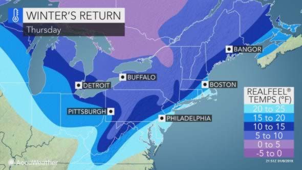
While chilly winds are sweeping across the northeastern United States into Monday, a more far-reaching, bitter and longer-lasting shot of cold awaits later this week.

The brisk winds that had people in the Northeast bundling up to head to work or school on Monday morning is a sign of things to come for later this week.

Temperatures are set to rebound on Tuesday, following snow and a wintry mix on Monday night.

The warmup will be short-lived, however.

During Tuesday afternoon, showers, some with thunder and lightning are forecast to become locally heavy and gusty.

Wintry mix
(AccuWeather)

These showers will then roll across the central Appalachians during Tuesday night. Gusts may be strong enough to knock over a few trees and cause sporadic power outages.

As the colder air catches up to the back side of the showers, rain may change to a period of accumulating snow over the higher elevations of the central Appalachians Tuesday night.

Not only can more snow unfold from around the eastern Great Lakes to northern New England, but many more areas will be left shivering by the arctic plunge that follows.

The cold, driven by blustery winds, will begin to plunge into the Midwest on Tuesday before sweeping to the mid-Atlantic and Northeast Wednesday into Thursday.

“The impending Arctic blast will bring the coldest weather experienced in the Northeast for a few weeks,” AccuWeather Senior Meteorologist Joe Lundberg said, “and the cold will not just last a day or two but for several days.”

Outside of the St. Lawrence Valley, AccuWeather Lead Long-Range Meteorologist Paul Pastelok does not anticipate this cold shot to bring significant departures from normal in the Northeast.

“It will be typical January cold, but that can still be a big shocker for residents and force higher energy demand,” he said.

Thursday will have significant shock value to residents who have gotten accustomed to the recent mild weather across the Interstate 95 corridor.

High temperatures this day may not be too far from normal, but blustery winds will hold AccuWeather RealFeel® Temperatures to the 20s from Boston to New York City to Baltimore and Washington, D.C.

That will come less than 48 hours after temperatures can climb to well into the 40s in Boston and New York City and around 60 F in Washington, D.C., on Tuesday.

“Farther inland, the cold blast can touch off one of the more prolific lake-effect snow events that has occurred in more than a month,” Lundberg said.

Lake-effect snow showers and squalls are anticipated to develop in a west-to-east fashion downwind of the Great Lakes Tuesday into Wednesday and can last into Thursday.

There is a potential for a foot or more of snow in the typical snow belts located to the southeast of all five Great Lakes, as well as in the Laurel Mountains of Pennsylvania. Major disruptions to daily routines, as well as school closures, can be anticipated.

Anyone planning to travel on stretches of I-90 from near Syracuse, New York, to Cleveland, Ohio, I-80 in western Pennsylvania and northeastern Ohio, I-75 in northern Michigan and other area interstates and roads should be prepared for difficult travel.

Snow squalls can cause rapid whiteouts and slick road conditions. These adverse conditions are notorious for causing chain-reaction accidents, potentially 100 to 200 miles away from the lakes.

Closer to the lakes, road crews may struggle to keep up with intense snowfall rates. Anyone who must travel during this time should have a winter survival kit in the event they become stranded.

The snow will be a boon to the ski resorts that have had to cut back on the number of slopes open.

While the lake-effect snow and biting winds should abate by Friday, Lundberg anticipates cold to hold in the Northeast through next weekend.

“The cold should fade next week, but this is a warning shot for winter’s return late in the month and early February,” he added.

Download the free AccuWeather app to find out the temperature trends for the upcoming week in your community.


ARCHIVES